
This record is maintained as part of the u.s. offshore dem collection. Read the documentation before using the files in a new analysis.这条记录属于美国离岸 DEM数据集。将文件用于新的分析前,请先阅读相关文档。
Dataset overview
USA_OD_2025 is a 1/9 arc-second offshore digital elevation model for major U.S. coastal zones. The product is generated with DEM-AMSSRN, an asymmetric multi-scale super-resolution network designed to preserve continental-shelf geomorphology while recovering fine-scale coastal terrain detail.
The source data are the CUDEM 1/3 arc-second CONUS: NAVD88 offshore DEM, which provides approximately 10 m input resolution. DEM-AMSSRN enhances this input by a factor of 3 to produce a 1/9 arc-second grid at approximately 3 m resolution. The released product covers the East Coast, West Coast, Gulf Coast and Alaska where source coverage is available.
- CUDEMs provide 1/9 arc-second offshore topobathymetry at approximately 3 m and 1/3 arc-second bathymetry at approximately 10 m
- The source CUDEM collection contains 872 high-resolution offshore tiles, each 8112 x 8112 pixels
- Sixty representative tiles were selected across East, West and Gulf coastal morphologies for training and validation
- USA_OD_2025 reconstructs fine channels, sandbars, shoreline contours and coastal structures that are blurred in the 1/3 arc-second input
- The paper reports a mean RMSE of 0.01185, mean PSNR of 53.30 dB and mean SSIM of 0.995056 for DEM-AMSSRN
- The model reduces RMSE by up to 72.47% compared with SRGAN in the evaluated U.S. coastal tests
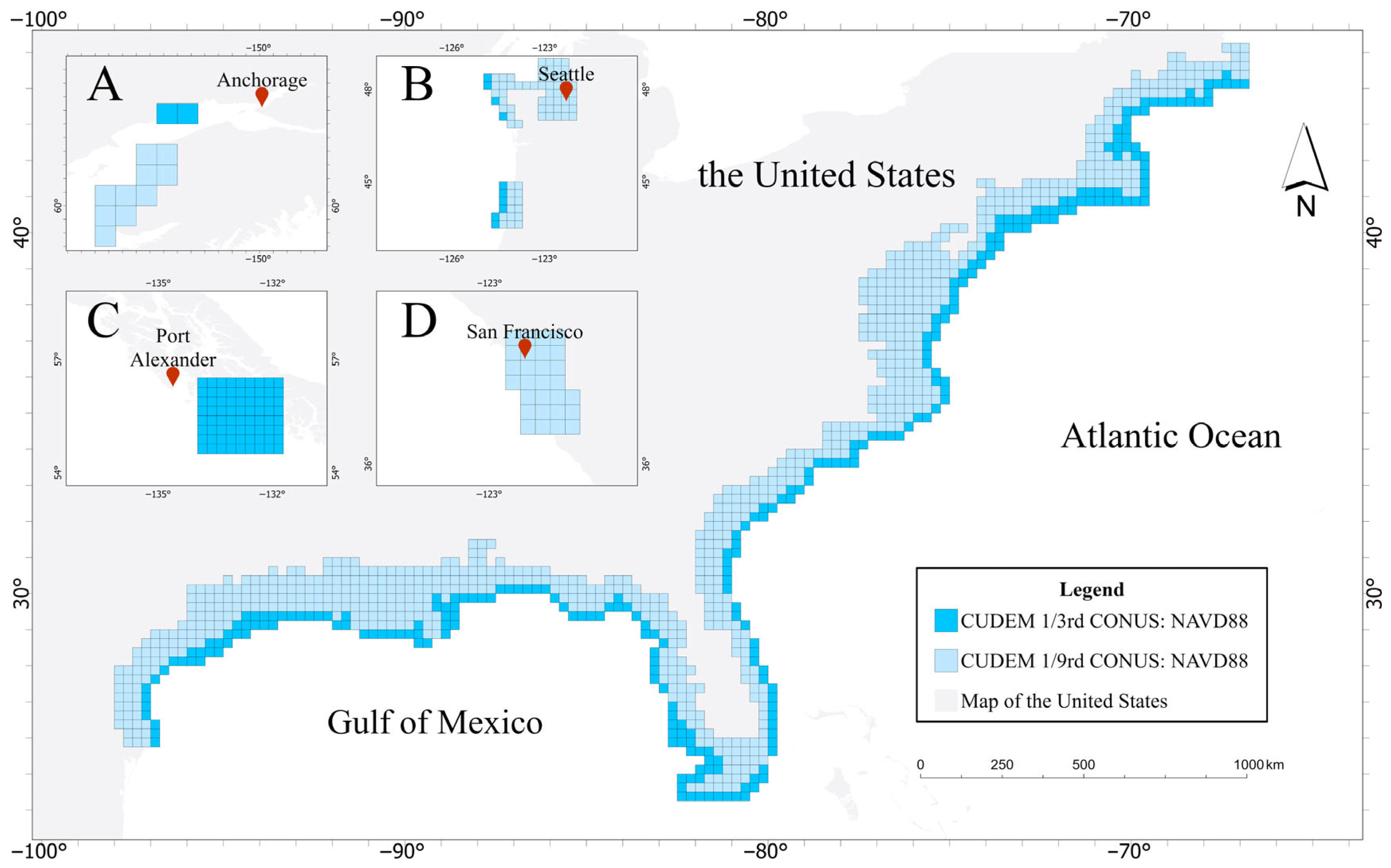
Data sources and preprocessing
| Dataset | Role | Resolution | Coverage and use |
|---|---|---|---|
| CUDEM 1/9th CONUS: NAVD88 | High-resolution reference | 1/9 arc-second | 872 offshore tiles covering the major U.S. coastal domain |
| CUDEM 1/3rd CONUS: NAVD88 | Low-resolution input | 1/3 arc-second | Input to the trained model for the USA_OD_2025 product |
| CUDEM 1/9th Hawaii, Puerto Rico, USVI, Guam, CNMI and American Samoa | Regional CUDEM variants | 1/9 arc-second | Catalogued coastal products described by the paper but not used as the primary training subset |
| CUDEM 1/3rd regional variants | Regional low-resolution products | 1/3 arc-second | Companion source products for regional coastal coverage |
The study selects 60 tiles from the full CUDEM collection to represent diverse East Coast, West Coast and Gulf Coast features while keeping training computationally manageable. Fifty tiles are used for training and ten for validation. Each 8112 x 8112 high-resolution training tile is divided into 96 x 96 target patches, with corresponding 32 x 32 low-resolution inputs created by bicubic downsampling at a factor of 3. A training tile yields 352,800 target patches.
Validation tiles are center-cropped to 6480 x 6480 pixels, downsampled to 2160 x 2160 pixels and divided into 60 x 60 low-resolution patches. Each validation input receives a 20-pixel mirror border, creating a 100 x 100 context window that reduces boundary artifacts during reconstruction. The elevation data use Z-score normalization to preserve local relief and avoid compressing the natural dynamic range.
Method
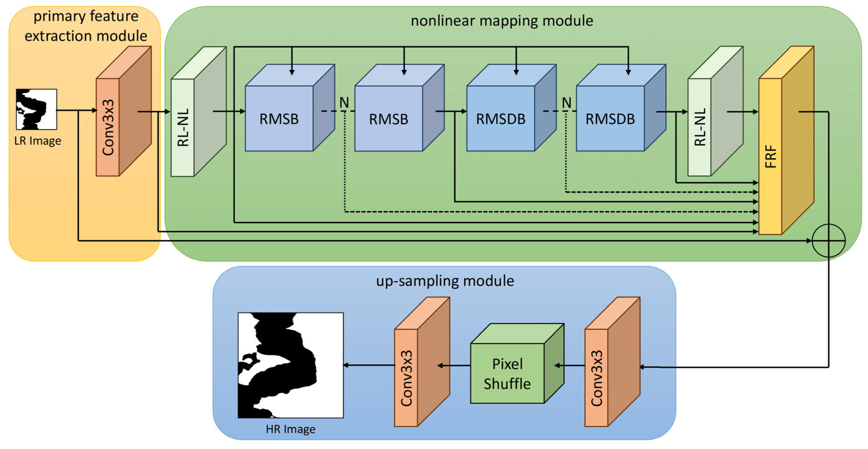
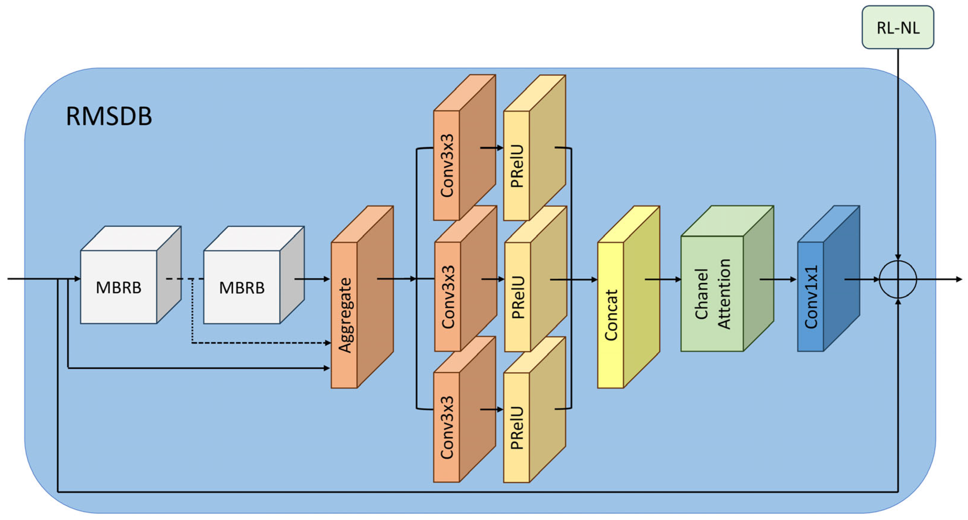
DEM-AMSSRN adapts an asymmetric multi-scale super-resolution network to offshore DEM reconstruction. It combines a primary feature extraction module, a nonlinear mapping module and a precision upsampling module. The nonlinear mapping stage uses region-level non-local modules, residual multi-scale blocks and residual multi-scale dilation blocks to model long-range spatial dependency, hierarchical terrain structure and enlarged receptive fields.
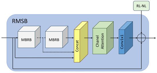
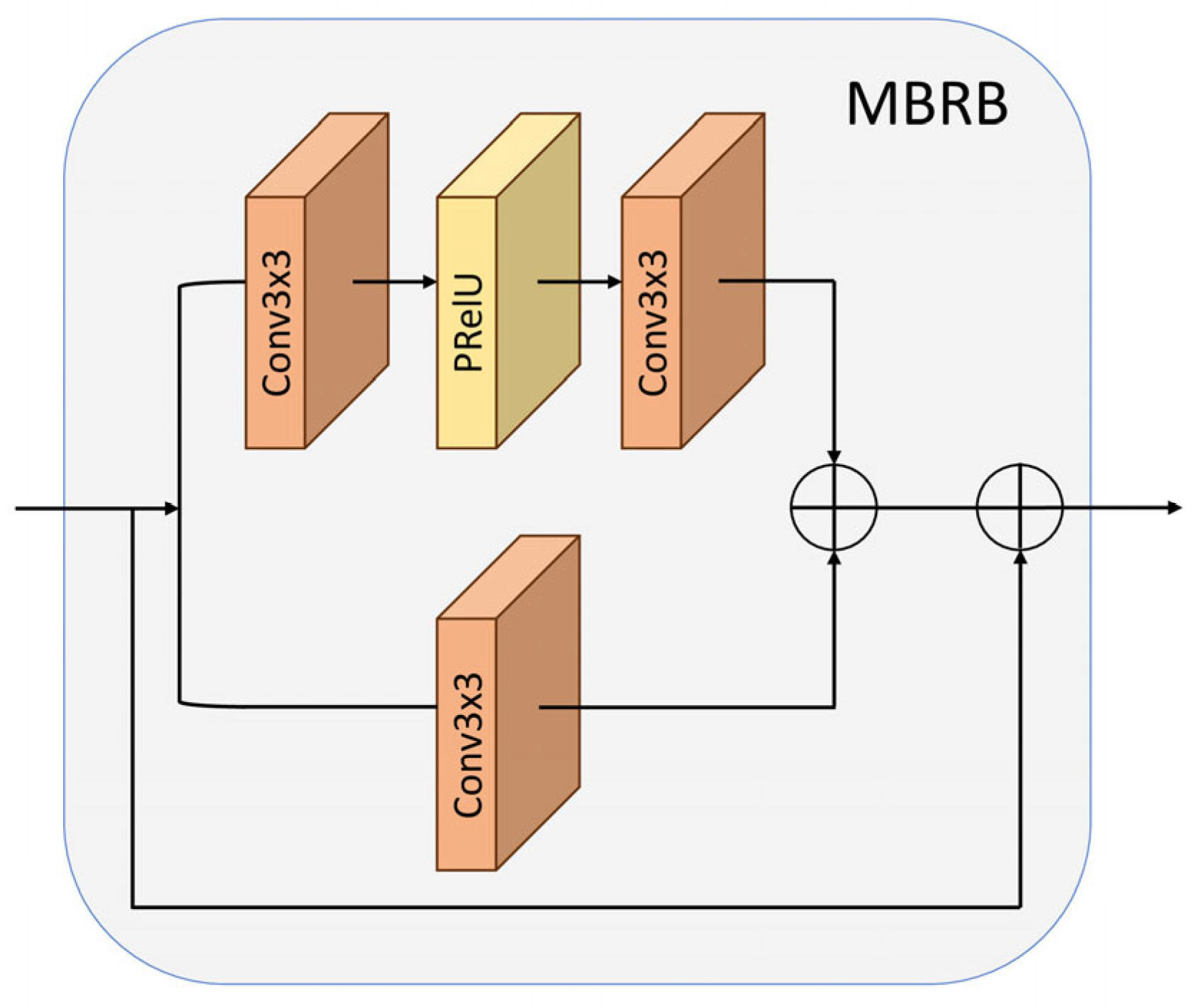
The residual multi-scale block is built from parallel multi-branch residual blocks. Each branch extracts local features with convolutional paths, merges the outputs with channel attention and preserves low-level information through residual connections. The residual multi-scale dilation block extends this design with dilated convolutions, enabling the network to combine local shoreline detail with broader shelf-scale context. A feature refinement fusion module combines shallow and deep features before PixelShuffle upsampling.
The training objective is a hybrid loss that combines pixel-wise L1 loss, VGG-19 perceptual loss and relativistic adversarial loss. The reported weighting coefficients are alpha = 100 for the pixel term, beta = 1 for the perceptual term and gamma = 0.1 for the adversarial term. The compared baselines are SRGAN, SRAGAN, NDSRGAN and SRADSGAN. GAN baselines use WGAN-GP, spectral normalization and adaptive learning-rate reduction when validation MSE degrades.
The main experiments use Adam with beta1 = 0.9 and beta2 = 0.999, a batch size of 64, 300 epochs and initial generator and discriminator learning rates of 1 x 10^-4. DEM-AMSSRN contains 23.63 million parameters and requires approximately 170,544 seconds for training in the reported environment, substantially less than the GAN baselines.
Validation and results
The paper evaluates RMSE, PSNR and SSIM on ten representative U.S. coastal test regions. Bicubic interpolation and four GAN-based super-resolution baselines are compared with DEM-AMSSRN at a 3x scale factor. The model reaches the lowest mean RMSE, the highest mean PSNR and the highest mean SSIM across the reported tests.
| Metric | Bicubic | DEM-AMSSRN | Interpretation |
|---|---|---|---|
| Mean RMSE | 0.01936 m | 0.01185 m | Lower reconstruction error |
| Mean PSNR | 51.67 dB | 53.30 dB | Higher signal fidelity |
| Mean SSIM | 0.994322 | 0.995056 | Stronger structural similarity |
| TEST10 RMSE | 0.06550 m | 0.03206 m | Better performance in a complex urban coastal region |
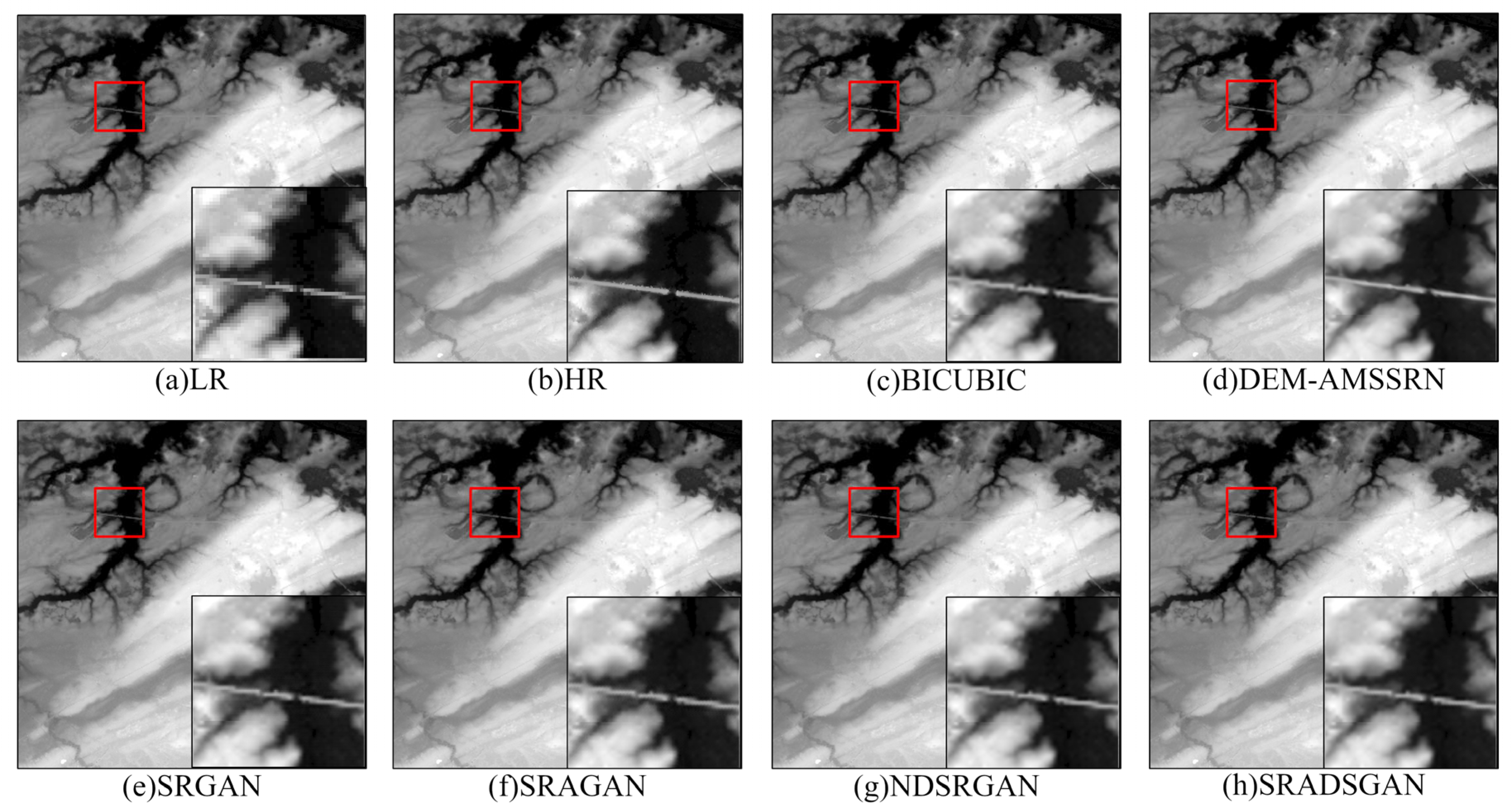
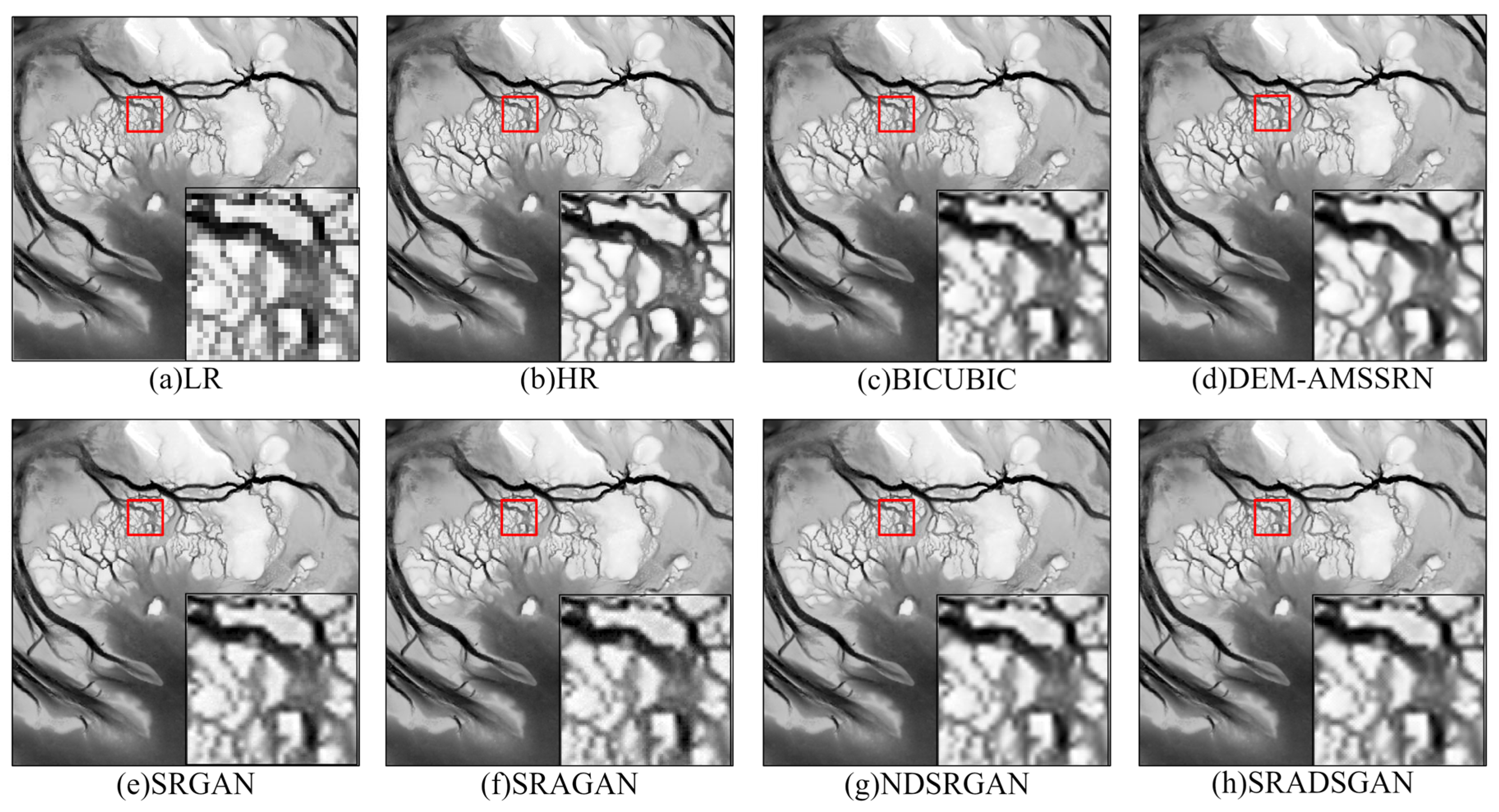
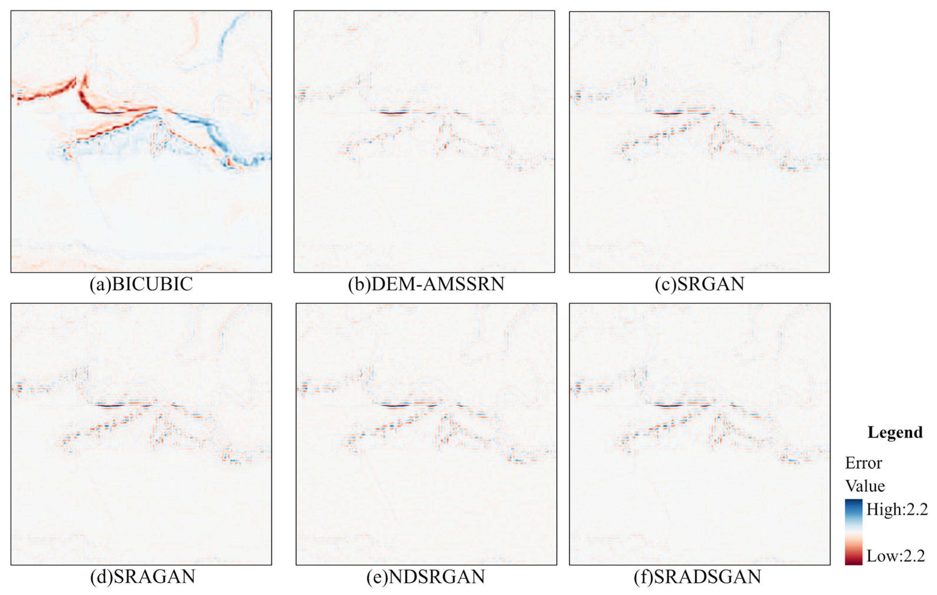
DEM-AMSSRN reconstructs clearer coastlines, sandbars, tidal channels and built structures than bicubic interpolation. On TEST5, the method preserves small tributary patterns and shoreline contours with fewer artifacts. On TEST7, it recovers narrow tidal channels, mudflats and levee alignments more continuously. Error maps for TEST8 show lower and more smoothly distributed residuals than the compared methods.
Output and access
USA_OD_2025 is a 1/9 arc-second approximately 3 m GeoTIFF offshore DEM covering major U.S. coastal zones where CUDEM source coverage is available. Dataset files are supplied through the access request form on this page. The paper, model implementation and source-data references are recorded in the project documentation for research use.
数据集概览
USA_OD_2025 是一套面向美国主要沿海区域的 1/9 弧秒离岸数字高程模型。该产品使用 DEM-AMSSRN 非对称多尺度超分辨率网络,在保留大陆架地貌结构的同时恢复细尺度沿海地形。
源数据为 CUDEM 1/3 弧秒 CONUS NAVD88 离岸 DEM,输入分辨率约为 10 米。DEM-AMSSRN 将输入放大 3 倍,生成约 3 米分辨率的 1/9 弧秒网格。产品覆盖东海岸、西海岸、墨西哥湾沿岸以及有源数据覆盖的阿拉斯加区域。
- CUDEM 提供约 3 米的 1/9 弧秒离岸地形测深产品与约 10 米的 1/3 弧秒测深产品
- 完整 CUDEM 源数据包含 872 个高分辨率离岸数据块 每个数据块为 8112 x 8112 像元
- 从东海岸、西海岸与墨西哥湾沿岸选择 60 个具有代表性的区域用于训练与验证
- USA_OD_2025 能够恢复 1/3 弧秒输入中被模糊的细沟道、沙坝、海岸线轮廓与沿海结构
- 论文报告 DEM-AMSSRN 的平均 RMSE 为 0.01185 平均 PSNR 为 53.30 dB 平均 SSIM 为 0.995056
- 在论文测试区域中 相比 SRGAN 的 RMSE 最大降低 72.47%
数据来源与预处理
| 数据集 | 作用 | 分辨率 | 覆盖范围与用途 |
|---|---|---|---|
| CUDEM 1/9th CONUS: NAVD88 | 高分辨率参考 | 1/9 弧秒 | 覆盖美国主要沿海区域的 872 个离岸数据块 |
| CUDEM 1/3rd CONUS: NAVD88 | 低分辨率输入 | 1/3 弧秒 | USA_OD_2025 模型推理使用的输入 |
| CUDEM 1/9th Hawaii、Puerto Rico、USVI、Guam、CNMI 与 American Samoa | 区域 CUDEM 变体 | 1/9 弧秒 | 论文列出的区域沿海产品 未作为主要训练子集 |
| CUDEM 1/3rd 区域变体 | 区域低分辨率产品 | 1/3 弧秒 | 配套的区域沿海源数据 |
研究从完整 CUDEM 集合中选择 60 个数据块,覆盖东海岸、西海岸和墨西哥湾沿岸的不同地貌类型,在保持代表性的同时控制训练成本。50 个数据块用于训练,10 个用于验证。每个 8112 x 8112 的高分辨率训练数据块被切分为 96 x 96 的目标块,再通过 3 倍双三次下采样生成对应的 32 x 32 低分辨率输入。每个训练数据块可生成 352800 个目标块。
验证数据块先中心裁剪为 6480 x 6480 像元,再下采样为 2160 x 2160 像元,并切分为 60 x 60 的低分辨率块。每个验证输入增加 20 像元镜像边界,形成 100 x 100 的上下文窗口,以减少卷积边界造成的重建伪影。高程数据使用 Z-score 标准化,保留局部起伏并避免压缩自然高程范围。
方法
DEM-AMSSRN 将非对称多尺度超分辨率网络改造用于离岸 DEM 重建,由主要特征提取模块、非线性映射模块和精确上采样模块组成。非线性映射阶段使用区域级非局部模块、残差多尺度块和残差多尺度空洞块,同时建模远距离空间依赖、层级地形结构与更大的感受野。
残差多尺度块由并行的多分支残差块构成。每个分支通过卷积路径提取局部特征,再使用通道注意力进行融合,并通过残差连接保留低层信息。残差多尺度空洞块在此基础上加入不同膨胀率的空洞卷积,使网络能够同时利用局部海岸细节与更大尺度的大陆架背景。特征精化融合模块在 PixelShuffle 上采样之前整合浅层与深层特征。
训练目标是由像元级 L1 损失、VGG-19 感知损失与相对式对抗损失组成的混合损失。论文报告的权重为 alpha = 100、beta = 1、gamma = 0.1。对比方法包括 SRGAN、SRAGAN、NDSRGAN 与 SRADSGAN。GAN 基线使用 WGAN-GP、判别器谱归一化,并在验证 MSE 连续变差时自适应降低学习率。
主要实验使用 Adam 优化器,beta1 = 0.9、beta2 = 0.999,批大小为 64,训练 300 个 epoch,生成器与判别器初始学习率均为 1 x 10^-4。DEM-AMSSRN 包含 2363 万个参数,论文环境中的训练时间约为 170544 秒,明显短于 GAN 基线。
验证与结果
论文在 10 个具有代表性的美国沿海测试区域上使用 RMSE、PSNR 与 SSIM 评价结果,并以 3 倍尺度比较双三次插值与四种 GAN 超分辨率基线。DEM-AMSSRN 在报告的测试中取得最低平均 RMSE、最高平均 PSNR 与最高平均 SSIM。
| 指标 | 双三次插值 | DEM-AMSSRN | 说明 |
|---|---|---|---|
| 平均 RMSE | 0.01936 米 | 0.01185 米 | 重建误差更低 |
| 平均 PSNR | 51.67 dB | 53.30 dB | 信号保真度更高 |
| 平均 SSIM | 0.994322 | 0.995056 | 结构相似度更高 |
| TEST10 RMSE | 0.06550 米 | 0.03206 米 | 在复杂城市沿海区域表现更好 |
相比双三次插值,DEM-AMSSRN 能够更清楚地恢复海岸线、沙坝、潮汐沟道与人工结构。在 TEST5 中,模型保留了细小支流纹理与海岸线轮廓并减少伪影。在 TEST7 中,模型对狭窄潮汐沟道、泥滩与堤坝线状结构的恢复更加连续。TEST8 误差图显示,DEM-AMSSRN 的残差更低且分布更平滑。
输出与获取
USA_OD_2025 是一套约 3 米分辨率的 1/9 弧秒 GeoTIFF 离岸 DEM,覆盖有 CUDEM 源数据的美国主要沿海区域。数据文件通过本页的申请表获取,论文、模型实现与源数据说明已记录在项目文档中供研究使用。
04 / ACCESS REQUEST04 / 数据申请
Request the data.申请数据
Tell us who you are and how you plan to use this record. Every file in this dataset will be included in the request.请告诉我们你的身份以及使用这条记录的计划。本数据集中的全部文件都会包含在申请中。